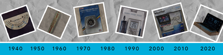
What is Wind Chill?

What is Wind Chill?

The wind chill is a measure of how cold it really feels outside. The wind chill formula relies on environmental data including the wind speed and the ambient air temperature, and is only calculated when temperatures drop below 32 degrees Fahrenheit (0 degrees Celsius).

Wind chill makes it feel colder than it really is due to the loss of body heat when exposed skin is in direct contact with the wind and cold temperatures. Heat is drawn away from the body at a faster rate when wind speed increases. For example, your weather station may report that the outdoor temperature is 20 degrees Fahrenheit (-7 degrees Celsius) with a wind speed of 10 mph (16 kph). The temperature at which these two values intersect is the wind chill. In this example, it will feel like it is 9 degrees Fahrenheit (-13 degrees Celsius).

NWS Wind Chill Chart

In extreme environments, this can lead to dangerous conditions such as frostbite or hypothermia. Frostbite is the freezing of the skin and body tissue just below the skin, first affecting body parts with limited circulation such as fingers, toes, noes and ears. To reduce the likelihood of frostbite, make sure all skin is covered with hats, gloves, face protection and appropriate boots. The shaded areas in the chart above show the estimated time for frostbite to develop on exposed skin.

Prolonged exposure to these extremely cold environments increases the chance of hypothermia. Alternatively, in warmer temperatures from 30 to 50 Fahrenheit (-1 to 10 Celsius), if you or your clothing gets wet, hypothermia can become a dangerous threat.

Be prepared for diagnosing and treating frostbite or hypothermia by visiting the Mayo Clinic articles on frostbite symptoms and treatment or hypothermia.

February 19, 2018
Comments
Blog Comments